
Friday, 14 October 2016
Urban Lacunarity Analysis of Medium-Size Brazilian Cities
Open spaces of cities play a key role at ensuring environmental sustainability and also at the restructuring of its urban territory. Evaluating the distribution of those spaces in the cities is a necessary requirement in the definition of guidelines for Public Master Plans. In this context, this paper aims to evaluate the distribution of the open spaces in 10 similar-sized brazilian cities, whose morphologies are the result of different processes of occupation and urban growth by using the multiscalar measure of lacunarity, complementary to the fractal dimension, which allows to distinguish different spatial patterns of density, packaging, dispersion and permeability. The values of lacunarity were obtained from georeferenced binary images of each city’s major urban areas. The results demonstrate that almost all
of the cities have lacunarity curves with concave down, associated with the presence of well-dispersed open spaces
among their urban areas.
 This paper was presented at Portuguese-language Network of Urban Morphology (PNUM) in Guimarães, Portugal from 15 to 16 July 2016.
Saturday, 4 July 2015

Monday, 29 June 2015
LACUNARITY OF PUBLIC OPEN SPACES: THE CASE OF CAMPINA GRANDE, PB
This paper presents preliminary results of an ongoing research which aims to evaluate the distribution of Public Open Spaces (POS) in Campina Grande – PB, Brazil. The research consisted of three main stages: (i) identification, mapping and classification of POS; (ii) preparation of thematic maps of the physical, environmental, socioeconomic and urban planning conditions; and (iii) lacunarity calculation of POS considering the urban area of the municipal district. The obtained lacunarity graphs reveal a strong concentration of POS in the central areas of the city, already well served of urban infrastructure and housing a population with better income. Therefore, the results show that the city’s POS are more accessible to a more privileged portion of the population, leaving the others at a loss.
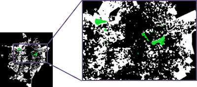


Figure 1. Binary map of Open Spaces (white) and Public Open Spaces (Green) of Campina Grande, PB

Figure 2. Lacunarity graphs of the Open Spaces (blue line) and Public Open Spaces (red line) of Campina Grande, PBThe paper was presented at X Colóquio do QUAPÁ-SEL which was held in Brasília, Brazil from 23 to 24 June 2015.
URBAN MORPHOLOGY AND (PUBLIC AND PRIVATE) OPEN SPACES IN CAMPINA GRANDE, PB
The accelerated process of transformation of morphological patterns in cities - based on verticalization and urban sprawl through the implantation of new vertical and horizontal condos – has been the great brand of the Brazilian urbanization process in the last decades. In Campina Grande, this phenomenon is particularly seen in a medium-sized city (with about 380 inhabitants) with a compact configuration. Naturally, one can make an association of these morphological changes with the situation of its public and private open spaces. This paper aims to evaluate the location and distribution of Public Open Spaces (PuOS) and Private Open Spaces (PrOS) in the urban structure of the city, considering its existing urbanization patterns. The analyzes were based on the results of Quapá-SEL workshop in Campina Grande (2013), on census data, on the characterization of symbolic spaces and on a situational analysis of spatial typologies, systematized through geoprocessing tools. It is verified an inadequate distribution of PuOS in Campina Grande that are concentrated in central areas which already provided better urban infrastructure conditions.


Figure 1. Map of Vertical Condos IndexThe paper was presented at X Colóquio do QUAPÁ-SEL which was held in Brasília, Brazil from 23 to 24 June 2015.
Tuesday, 21 October 2014
SIMULATING THE DYNAMICS OF LAND COVER CHANGES IN THE MUNICIPALITY OF SÃO JOÃO DO CARIRI
São João do Cariri is a municipality located in the Cariri Oriental microregion of the state of Paraíba (figure 1) which has been suffering significant land use and land cover changes. The extensive cattle raising, the deforestation for multiple purposes, the intense and permanent land use in small properties, the burned-over land to clean and prepare the land for planting, and the inadequate irrigation process may provoke serious impacts on its socioeconomic and physic-environmental conditions.


Figure 1. Location of São João do Cariri in the Northeast of Brasil (Pereira et al, 2010).In this context, the present paper aims to construct a descriptive model to simulate the dynamics of land cover change in the municipality of São João do Cariri through the elaboration of land cover maps, generated by LANDSAT 5 TM images from different datas. The methodological procedures done and the obtained results persue to assist on decision making processes of planners, managers, and public administrators, as well as to be a reference for simulations of land use and land cover changes to be applied in other municipalities of the region. The results (figure 2) reveal that, for almost 30 years (from 1987 to 2008), happened an accelareted desertification process in the territory with a drastic reduction of the vegetation coverage and the hydric surface of the municipality.

Figure 2: Land coverage changes in São João do Cariri from 1987 to 2008.The paper was presented at Congresso Luso-Brasileiro para o Planejamento Urbano, Regional, Integrado e Sustentável - PLURIS 2014 which was held in Lisboa, Portugal from 24 to 26 September 2014.
Monday, 28 July 2014
SEGMENTED CITIES WITH FUZZY WALLS: CHANGES IN INFORMAL SETTLEMENTS AS SEEN THROUGH A MULTISCALE ANALYSIS
Cities can be seen as complex urban mosaics made up of a set of fragments that reflect the social inequalities among their residents, and, at the same time, change their actions and decisions. These mosaics are easier to see in metropolises in the less developed world, as in these urban regions, one does not need to be an urban planner or an old city dweller to see that some areas are more attractive, privileged, and better serviced than others. The bigger and more populated a city is, the more visible its social inequalities are likely to be. The fragments of the urban mosaic are divided by walls. Some walls are visible, tangible, and concrete barriers resulting from the built and natural environment. Other walls are intangible or invisible barriers imposed by zoning and social prejudice (Marcuse 1995). The rigidity of the city’s walls may vary according to the scale through which they are analyzed.
In this context, the present paper aims to discuss the segmented city in the less developed world, focusing on one particular type of urban fragment: informal settlements. These settlements can be defined as urban areas that have been developed outside the official land use laws and regulations. In general, such areas are occupied by the poor who have not been able to buy, sell or rent a household in the city’s formal real estate market. Normally, these households are built spontaneously, without a previous plan to guide or control the land occupation. The result is the generation of a set of ‘places’ more than just ‘spaces’ - since these places inherently have a strong set of social relations among their inhabitants (Norberg-Schulz 1971), and their morphologies may vary significantly from the formal urban spaces – and it is also possible to say that formal cities have fewer ‘places’ and more ‘spaces’ for the same reason as previously mentioned.
The main assumption of the paper is that the walls of informal settlements change from rigid to fuzzy ones, as they are analyzed using finer scales. In order to show this change this paper is divided into four sections. The first section analyzes the changes in two types of urban structure model: the segregated city model and the segmented city model. The former is a synthesis of the traditional ecological models of the Chicago School, as well as the Marxist core-peripheral model. The latter is an alternative and complementary model that reveals the dynamics of the contemporary Latin American metropolises as a result of the fragmentation of the previous segregated city model, and can be described by three basic features: the fractioning of the social classes; spatial roughness; and network-territories.
The second section describes the changes in governmental intervention models for informal settlements in Latin American cities, emphasizing what has been happening in the city of Recife, in Brazil. It shows that, since the 1980s, conventional slum eviction programs have been replaced by programs to upgrade slums. These changes have contributed to a much better understanding of the specificity and diversity of the informal settlements, as well as to ‘knocking down’ their previously rigid walls, and accepting the inevitability of their existence.
The third section investigates the fact that, despite the changes in terms of governmental intervention models for informal settlements, there are still limits on the official city maps that effectively impede any appropriate representation of them. These limits can be seen through the analysis of the features in the two main databases about the city of Recife: the Brazilian Demographic Census data and the city’s official cartographic base.
In order to show the gaps between the official cartographic representations and the reality of informal settlements, the last section of this paper analyzes in more depth the walls of one specific informal settlement in the city of Recife, Brazil, called Brasília Teimosa. This finer scale analysis allows us to see that its walls are even more fuzzy and permeable than the walls of the many formal settlements.
This paper was presented on the conference EVERYDAY LIFE IN THE SEGMENTED CITY held in Florence in 2011. It was also published in Research in Urban Sociology, volume 11, 2011.
Wednesday, 17 August 2011
A cidade como patrimônio cultural: Campina Grande, arquitetura e urbanismo
O programa de extensão A cidade como patrimônio cultural: Campina Grande, arquitetura e urbanismo se propõe a ser uma ação articulada com as atividades de ensino e pesquisa dos cursos de graduação e pós-graduação da Unidade Acadêmica de Engenharia Civil. Tem como principal objetivo conhecer, registrar, analisar e divulgar o acervo edificado tombado da região central de Campina Grande (PB), em parceria com o Instituto do Patrimônio Histórico e Artístico do Estado da Paraíba e com a Prefeitura Municipal de Campina Grande. Suas principais metas são: 1) inventariar as edificações do centro antigo campinense, 2) digitalizar os projetos arquitetônicos originais das edificações do perímetro de tombamento, 3) sistematizar e georeferenciar as informações coletadas 4) divulgar o banco de dados gerado através de cartilhas e meios eletrônicos. Para tanto, serão utilizados modelos de inventário, ferramentas digitais de captura, edição e sistematização de imagens, recursos computacionais e softwares de geoprocessamento. Todas essas ferramentas intentam a constituição de um banco de dados com informações que subsidiem estudos e estratégias de difusão, visando um planejamento urbano integrado à conservação e à valorização do patrimônio cultural da cidade como parte essencial da constituição do espaço urbano de Campina Grande, tanto por setores públicos quanto por iniciativas particulares. Esse banco de dados será disponibilizado em endereço eletrônico, facilitando o acesso à informação para a sociedade em geral.
Subscribe to:
Posts (Atom)
Urban Lacunarity Analysis of Medium-Size Brazilian Cities
Open spaces of cities play a key role at ensuring environmental sustainability and also at the restructuring of its urban territory. Evaluat...
-
 From left to right: Ana Lúcia Candeias, Mauro Barros Filho, Norma Lacerda, Luiz Amorim, Jan Bitoun, and Fabiano Sobreira.
 -
 Research group of UFCG at X Colóquio QUAPÁ-SEL from 23 to 24 June 2015 in Brasília, DF. From left to right: Ana Carla Lima, Joyce Xavier, K...
 -
 The accelerated process of transformation of morphological patterns in cities - based on verticalization and urban sprawl through the implan...