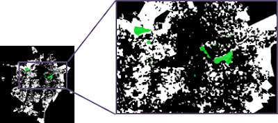
This paper presents preliminary results of an ongoing research which aims to evaluate the distribution of Public Open Spaces (POS) in Campina Grande – PB, Brazil. The research consisted of three main stages: (i) identification, mapping and classification of POS; (ii) preparation of thematic maps of the physical, environmental, socioeconomic and urban planning conditions; and (iii) lacunarity calculation of POS considering the urban area of the municipal district. The obtained lacunarity graphs reveal a strong concentration of POS in the central areas of the city, already well served of urban infrastructure and housing a population with better income. Therefore, the results show that the city’s POS are more accessible to a more privileged portion of the population, leaving the others at a loss.
Figure 1. Binary map of Open Spaces (white) and Public Open Spaces (Green) of Campina Grande, PB
Figure 2. Lacunarity graphs of the Open Spaces (blue line) and Public Open Spaces (red line) of Campina Grande, PB
The paper was presented at
X Colóquio do QUAPÁ-SEL which was held in Brasília, Brazil from 23 to 24 June 2015.


